Maps & Risk Assessment
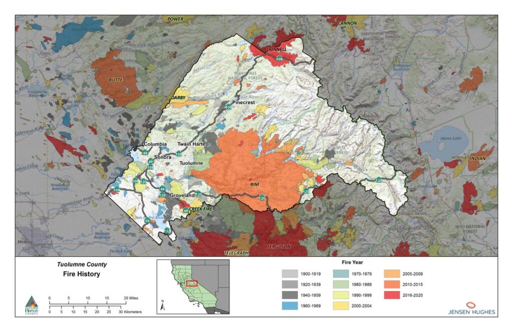
Fire History Map
This map illustrates historical wildland fires that have occurred in and around the Planning Area between 1900 to 2020. Data is from CAL FIRE.
This map illustrates historical wildland fires that have occurred in and around the Planning Area between 1900 to 2020. Data is from CAL FIRE.
Historic Fire Hot Spots:
This map illustrates where fire ignitions have historically occurred more often in the Planning Area. The “weighted” data considers where fire ignitions have occurred and resulted in large fires, whereas the “unweighted” data considers all ignitions independent of size of resulting fire. The underlying data is from the United States Forest Service (USFS) and includes ignitions from 1900 through 2021.
Fire Frequency:
This map illustrates the relative frequency of wildland fires based on historical incidents that have occurred in the Planning Area between 1900 to 2021. Relative frequency is approximated by aggregating the number of times a fire has burned in a given area. Fire history data was obtained from CAL FIRE.
Burn Probability:
Burn Probability quantifies the relative likelihood of a fire occurring in the landscape under a fixed set of weather and fuel moisture conditions. In this map, weather and fuel moisture conditions are based on the 97th percentile. The underlying analysis depicted in this map was generated using IFTDSS (Interagency Fuel Treatment Decision Support System) and LANDFIRE (Landscape Fire and Resource Management Planning Tools) input data.
Flame Length:
Conditional Flame Length is an estimate of the mean flame length (in feet) for all fires that burn a given point on the landscape given current vegetative conditions, extremely dry fuel moistures, and peak winds. This metric is often used as a proxy for fire intensity. Model inputs for dead fuel and live fuel moisture are based on 97th percentile conditions obtained from 20 years of weather records from
remote automated weather stations (RAWS) during core fire season.
Integrated Hazard
Integrated Hazard is the combination of burn probability and conditional flame length into a single metric that provides a more comprehensive summary of wildfire risk (i.e., considers both likelihood that fire will occur and at what intensity). Integrated hazard is categorized into seven distinct classes, where the first two are for areas that did not burn and the remaining five classes provide a relative indication of wildfire risk (i.e., likelihood x fire intensity). Integrated hazard is oftentimes a primary metric for wildfire resiliency and preparedness decision-making.
Tuolumne FireSafe Council, Inc.
P.O. Box 692
Tuolumne, CA 95379-0692
info@tuolumnefiresafe.org
The TFSC is dependent on grant funding and donations. Help us reduce the risk of wildfires.
Sign up for news and information about fire safety in Tuolumne County.
Copyright © 2023–2026 Tuolumne Fire Safe Council • Website by Webdancers